May your desire to travel and enjoy one of the worldMay your desire to travel and enjoy one of the world’s most iconic cities not be overshadowed by not knowing how the transportation system in London works.
We know what it feels like to arrive in such a large city for the first time, so we have prepared this mega guide to help you navigate each type of transportation.
Discover here how to avoid taking the metro in the wrong direction or getting on a bus route that won’t take you to your destination.
Be amazed by all the transportation solutions you can choose from in London. Choose the combination that best suits you to have a fabulous experience in this dream city and save on your budget.
Let’s see what the mobility solutions in London are, the fares, schedules, and payment options you can choose for a fantastic trip.
- Transport Cards in London
- What Are the Best Transport Options in London?
- How to Travel to Central London from the Airports?
- Why is the Metro the Most Popular Means of Transport?
- Traveling by Train in London
- Trams or Tramlink South London
- Travel on London’s Iconic Buses
- Travel by Bicycle and Enjoy London to the Fullest
- How to Rent a Bicycle in London
- River Transport in London
- Emirates Line
- Taxi Service in London
- Travel and Experience a Fascinating Adventure in London
Transport Cards in London
Before we start talking about each of the modes of transport you can use in London, it is important to know the main travel cards and their benefits.
Although in the London Underground you can buy individual tickets, the most practical way to save is to use prepaid cards, as they can be used to pay across the entire integrated system.
This means that they are useful for the metro, trains, and buses. There are several types of cards, but the most used are the following:
Oyster Card
This is a prepaid system where fares are deducted based on your journeys on different modes of transport in London.
You should know that with this card, a metro journey between zones 1 and 2 costs £2.40, while a bus ride costs £1.50.
The good news for tourists is that with the Oyster Card, if you only travel within zones 1 and 2, which is the city’s epicenter, the daily spending limit is £6.60 per day. Once that limit is exceeded, additional trips are free on that same day.
This card has two versions. The blue one that you can get once you arrive in London and the visitor one, which is colorful with a “visitor” mark and you can buy it online.
The latter has an activation cost of 5 pounds and is non-refundable, while with the regular one, you can recover the deposit and any remaining balance at the end of your visit to the city.
You can buy the Oyster card at the airport, but you might have to wait in line. If you want to avoid this, then the option is to buy it online and pay the activation fee.
London Travelcard
The London transportation system also has the Travelcard. You can get preloaded cards for one day, seven days, one month, and one year. Depending on the period purchased, you can travel unlimitedly.
This card is a good option if you need to travel frequently outside zones 1 and 2.
What Are the Best Transport Options in London?
If the London transportation system stands out for anything, it is the large number of options it offers for the mobility of its residents and tourists. These include:
• The London Underground
• Buses
• Trains
• Overground
• DLR (Docklands Light Railway)
• TfL (Elizabeth Line)
• Boats
• Tram
• Cable Car (Emirates Line)
How to Travel to Central London from the Airports?
But, from which of the six airports in London? Yes, you read that right, there are six. That gives you an idea of the size of the city.
In the following map, you can see the strategic location of each of the airports within the city. Take it into account to orient yourself when traveling to London and to design your routes when entering and leaving the city.
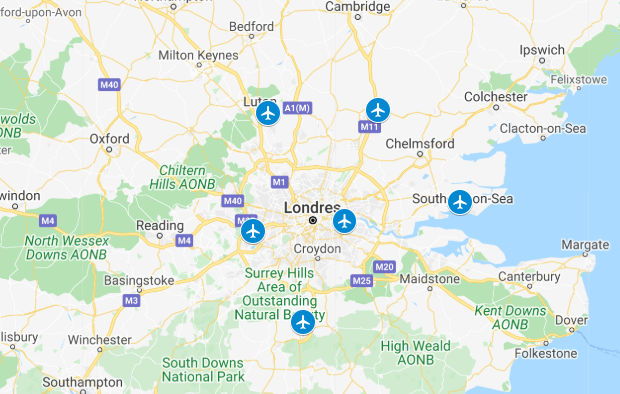
Below, we detail the transport options in London available at each of the airports, let’s see:
|
Airport |
Location |
Transport Options from the Airports |
||||||
|
Express |
TfL |
Metro |
Bus |
Minibus |
Taxi / Vehicle |
|||
|
Heathrow |
Hillingdon (Greater London) |
23 kilometers west of London |
|
|
 |
|
|
|
|
Gatwick |
Crawley (East Sussex County) |
48 kilometers south of London |
|
|
|
|
|
|
|
Stansted |
Stansted-Mountfitched (Essex County) |
60 kilometers northwest of London |
|
|
|
|
|
|
|
Luton |
Luton (Bedforshire County) |
45 kilometers north of London |
|
|
|
|
|
|
|
City |
Newham (Greater London) |
12 kilometers from London |
|
|
|
|
|
|
|
Southend |
Rochford-Southend-on-Sea (Essex County) |
60 kilometers east of London |
|
|
|
|
|
|
To get to your hotel or accommodation, you can use different transportation systems in London from each of these airports.
Your choice will depend on the budget you have available, the speed you want to travel, and of course, the scenery you want to enjoy.
Why is the Metro the Most Popular Means of Transport?
The Metro is not just a means of transportation in London; it is an icon of the city and one of the oldest in the world, operating since 1863. It is also the fourth longest in the world with a length of 400 kilometers of tracks.
It has a network of 11 lines where it is estimated that more than 5 million people travel daily, accessing through 270 stops.
This is not counting the Overground, DLR, and TfL Rail lines, which are also integral parts of the transportation system in London.
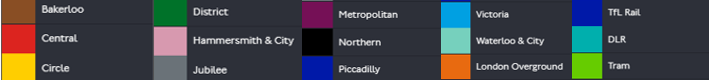
The Metro is the fastest and most economical transportation option in the city. What you should do before traveling on this medium is to take a look at the route diagram to orient yourself.
But first, take into account the colors that identify each line, as detailed below:
Use the following diagram to orient yourself when traveling on the London Metro.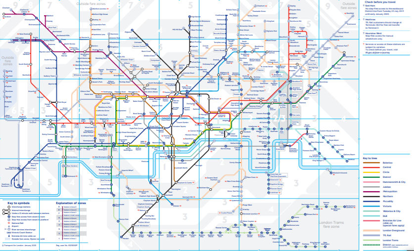 Choose a line and study its route in the diagram, this way you will familiarize yourself with the conventions of the diagram to identify the stations along its route.
London Metro route diagram updated January 2020. Source: https://tfl.gov.uk/maps
You can also download this diagram in the mobile version for smartphones or tablets.
Prefer apps that can be consulted offline, as internet access is restricted underground.
These are some of the most used applications by residents and tourists to facilitate their transportation in London. Click on the icon to download the application of your choice:
|
Applications |
Android |
iOS |
|
Citymapper |
||
|
Tube Map |
You can travel on the Metro from 5:00 AM to 12:00 PM. And remember that the most economical way to travel on the Metro is to use prepaid cards.
If you are a tourist, we recommend avoiding peak hours, as besides a great congestion due to the increased number of users, fares are higher.
As for the price you pay per trip, you should know that it will depend on the destination and the zones you travel in.
This transportation system in London is characterized by the distribution in zones, in a radar shape numbered from 1 to 9.
Zones 1 and 2 are the closest to the city center, and the fare will increase as you move away from the epicenter.
Traveling by Train in London
A complementary option to the Tube is the trains operated by National Rail, which are used to reach the outskirts of the city.
They have the advantage of using the same travel cards as the Tube and also make fewer stops.
At the following Tube stations, you can transfer to trains and bus services:
• King’s Cross, Victoria,
• Waterloo,
• Paddington,
• Liverpool Street.
Overground, DLR, and TfL Rail
As you can see in this list of Tube stations, it includes Overground, DLR, and TfL Rail stations.
These stations are managed by different entities but practically function as an integral part of the London transport system, the difference being that they are not underground.
They operate at the same times, and the fares are the same as the Tube. The Overground train circles central London and covers zones 2 to 4.
Meanwhile, the TfL line, which stands for Transport for London, crosses the city from east to west and is operated by Crossrail.
The DLR line is a small, driverless train. This route moves through the old Docklands port. The charm of this line is that it passes through the skyscrapers of the financial district in Canary Wharf.
Trams or Tramlink South London
The Tramlink South London or tram, although a bit further out, is also part of the city’s transport system.
It is less known because it is a line not near the city center. It is located in the south and connects the towns of Croydon and Wimbledon.
This line stretches over 28 kilometers and has 39 stations. You will recognize this line by a green circle and the inscription with the name: “Trams.”
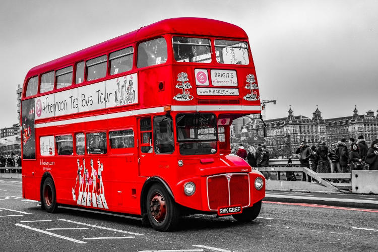
Travel on London’s Iconic Buses
If you’ve seen movies set in the streets of London, then you know that the red double-decker buses are unmistakable icons of the city.
If you want to tour the British capital on this fabulous transport, you should know that there are at least 700 lines.
This means you need to check which route will take you to your destination, so you don’t get lost in that intricate maze of transport routes in London.
Use the following diagram to guide you and select the appropriate route or routes to reach your points of interest on your trip.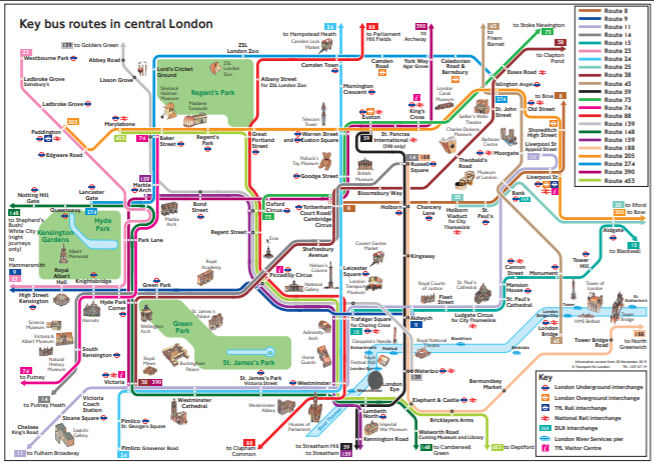
Bus routes in London. Source: https://tfl.gov.uk/maps
To travel by bus, the ideal is to use prepaid cards; with them, you will get better fares and they can be used across the entire London transport system.
You can even benefit from special offers and rates, as well as access to some of the city’s iconic tourist spots.
You can learn more about the London bus network in the guide we have prepared.
Travel by Bicycle and Enjoy London to the Fullest
If you like to get some exercise, a complementary option to the Tube and buses is renting a bike to enjoy the scenery and exercise at the same time.
London also offers its citizens and visitors a public bike rental system.
In the following map, you can check the available bike routes in the city:
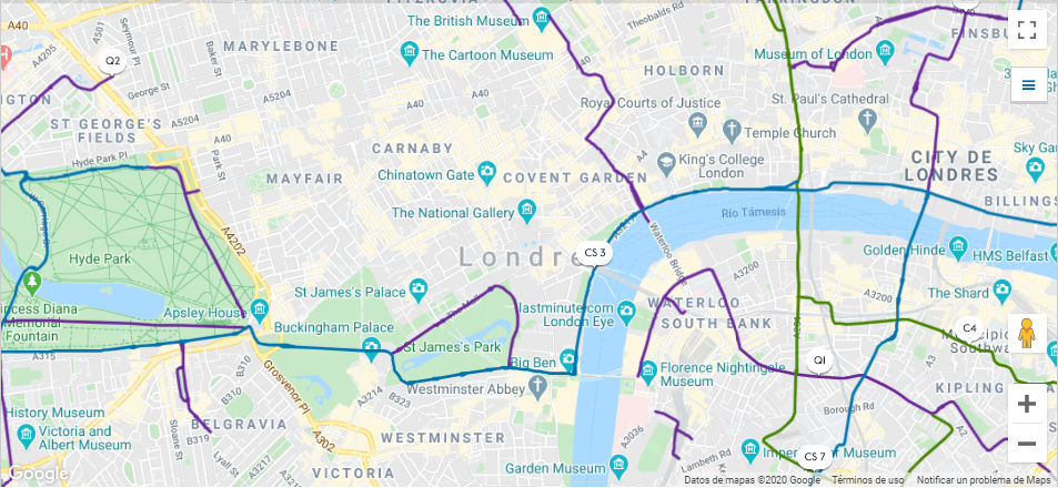
Diagram of London’s bike routes. Source: https://tfl.gov.uk/maps
To access this form of mobility, you only need a debit or credit card.
If you download the app, the rental process is much easier and faster, as it generates the release codes.
You can also check the availability of bikes and the nearest location to return them after your ride.
Additionally, with the app, you can monitor your usage and plan trips through favorite routes via an interactive map.
At the following links, you can download the Santander Cycle Hire app in its versions for iOS and Android.
To access this service, you must pay £2 for a 24-hour period and can make as many trips as needed. If the trip lasts less than 30 minutes, there will be no charge.
But if your trip extends, the charge is £2 for every 30 minutes. Remember that the bike must be returned within 24 hours after activating the service.
How to Rent a Bicycle in London
Renting a bicycle in London is very easy, just follow these steps:
1. Go to the nearest station and select the language on the screen.
2. Choose the option to rent a bicycle.
3. Insert the card into the reader slot to verify the access period, which can be 24 hours, a week, or a year. No charge is made at this step.
4. Reinsert the card to make the payment, according to the preferred period.
5. Select the number of bicycles you want to rent at once, a maximum of four.
6. Indicate the start date of the service, which can be immediate if you require it, and the access time will start counting.
7. A five-number code is printed to unlock the bicycle, and it is valid for 10 minutes.
8. Select the bicycle, enter the code, and pull it out firmly upwards and outwards.
9. To return the bicycle at the arrival station, just place the bicycle in the dock and make sure the green light turns on.
If the station where you want to return the bicycle is full, indicate in the application that the station is full. This will give you 15 additional minutes to go to the next closest station.
River Transport in London
One of the charms of this cosmopolitan city is traveling on the River Thames.
The transportation system in London has at least six boat lines and even a ferry that serves to cross from one side to the other, where you can take your rental car if traveling by this means.
The advantage of traveling by river is that you avoid traffic jams, which are inevitable when traveling by bus or vehicle through the city.
On the River Bus, besides enjoying a fantastic landscape, you find onboard coffee service and WIFI access.
Although this service can be paid in cash, they also accept the Oyster Card, making it very convenient and helping you save on fares.
The following diagram details the routes of each of the lines navigating the River Thames in London:
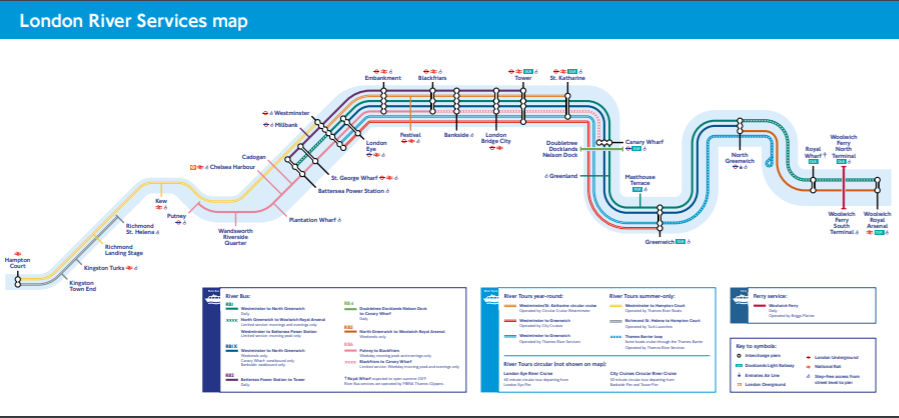
Diagram of river routes in London. Source: https://tfl.gov.uk/maps
Emirates Line
This transportation system consists of a cable car that travels over the River Thames and goes from Royal Victoria (DLR) to the Jubilee line of the metro or North Greenwich.
This is a line with more of an entertainment, fun, and tourist attraction objective than a transportation solution.
You can enjoy amazing landscapes on it, and if you go at sunset, you will have an extraordinary view.
This transportation service in London can also be paid with the Oyster Card.
Taxi Service in London
Like the double-decker buses, taxis in London are city emblems. Use them if your budget allows, as their price is quite high.
Taxi fares are determined by the time of day, distance, and speed.
As in many cities worldwide, if you prefer, you can request transportation service through apps like Uber, Free Now, Getty, and Addison Lee, among others.
Check which ones are available at the time of your trip and download the app of your choice in advance.
Travel and Experience a Fascinating Adventure in London
Now that you know how the transportation system in London works, you can prepare for your trip and make the most of all the options this wonderful city offers.
Choose your favorite places, design your travel plan, use the applications to create the best routes, and live fabulous adventures.
Share this guide so that many more travelers can get informed and prepare in advance to enjoy a magical trip and learn how transportation works in London. Count on us.